
Camera-Mounted LiDAR Capture for VFX Workflows
Hexagon's MANTIS by Leica Geosystems records scene geometry and camera tracking during filming, reducing depth reconstruction and matchmove work in post-production.
hexagon.com
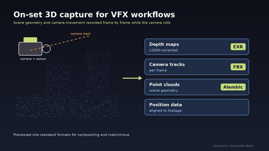
When a cinema camera records a shot, the image is preserved but most of the three-dimensional information about the set is not. Visual effects (VFX) teams then have to reconstruct depth, geometry and camera position after filming, using separate set scans, tracking markers or estimation from the footage itself. For complex shots that combine live action with computer-generated imagery (CGI), this reconstruction adds considerable time and complexity.
Hexagon has launched MANTIS by Leica Geosystems, a camera-mounted 3D capture and tracking system designed for film, television and other media production. It records scene geometry and camera movement while the camera is rolling, creating a spatial record aligned with each frame of the footage.
Why On-Set Spatial Data Matters
Productions increasingly combine physical sets with virtual environments and visual effects. Two of the most labour-intensive post-production tasks are matchmove, in which the motion of the real camera is reconstructed so that virtual objects can be placed correctly, and compositing, which needs depth information to integrate CGI elements behind or in front of real objects. Without measured data, both tasks rely on estimation.
How MANTIS Captures and Processes Scene Data
MANTIS is mounted on the camera and captures spatial data frame by frame during the take. The companion software, MANTIS Studio, processes the recorded data into LiDAR-corrected depth maps, camera tracks, position data and point clouds that are aligned with the footage.
"MANTIS records spatial data frame by frame on set, which enriches the images captured. This significantly reduces the steps required to composite live-action footage with CGI," said Chris Richter, President of Hexagon's Media & Entertainment Venture.
Integration Into Established VFX Pipelines
The outputs are delivered in standard formats used across the VFX industry, including EXR, FBX and Alembic, so they can be imported into existing compositing, tracking and 3D software without a proprietary pipeline. Hexagon describes MANTIS as the first system of its kind for spatial recording and processing in media and entertainment.
Burkhard Boeckem, Chief Technology Officer of Hexagon, explained the design rationale: "Almost every production today passes through tools that work in three dimensions, so we asked ourselves, why not include perfectly synced spatial data alongside the image?"
Availability
Hexagon demonstrated MANTIS at Infinity Festival in Los Angeles, held from November 12 to 15, 2026. Shipments are scheduled to begin in the first quarter of 2027.
Additional Context:
This section details technical specifications and competitive benchmarking not included in the original product announcement.
Until now, spatial data on film sets has typically been collected with stand-alone terrestrial laser scanners, photogrammetry, or optical camera-tracking systems that use markers or reference cameras. Laser scans deliver accurate static geometry but are captured separately from the take, while camera trackers record camera pose without scene depth. MANTIS combines both functions on the camera itself. The output formats it supports are established industry standards: OpenEXR for multi-channel image and depth data, FBX for 3D scene and camera exchange, and Alembic for baked geometry and animation caches. Hexagon has not published range, accuracy or weight specifications, so no quantitative comparison with other systems is made here.
Edited by Evgeny Churilov, Induportals Media - Adapted by AI.
